

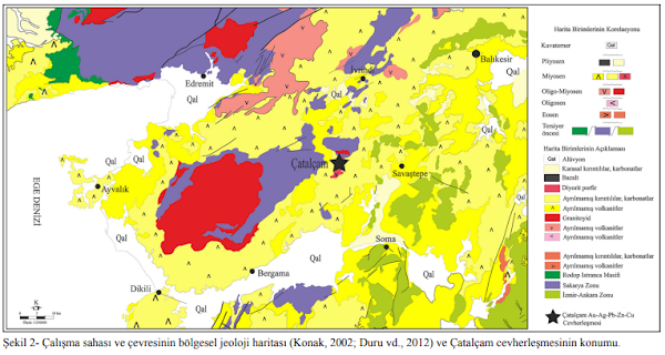
PROSPECTING GUIDELINES FOR CHROMITE DEPOSITS
Stratiform:
1.
Identify well layered mafic-ultramafic intrusions;
2.
Prospect below the mafic cumulate portions of the intrusions (i.e. below the
portion which
is
completely gabbroic).
Podiform:
1. Carefully prospect within all dunitic portions of Alpine-type peridotites (Harzburgite-Dunite
components of ophiolite complexes).
METHODS
Geophysical
Since
Podiform deposits are irregular in shape and unpredictable, gravity and
electrical methods
may
offer some promise as exploration tools. Some geophysical methods, such as
gamma-ray
spectrometry
and remote sensing, measure surface attributes; others, such as thermal and
some
electrical methods are limited to detecting relatively shallow features but may
help identify
features at greater depth. Secondary effects of deeper features, such as geochemical haloes,
can often be identified by these methods as given in Table 3.
Gravity method
Gravity
measurements define anomalous density within the Earth. In most cases,
groundbased
gravimeters
are used to precisely measure variations in the gravity field at different
points.
Gravity anomalies are computed by subtracting a regional field from the
measured
field,
which result in gravitational anomalies that correlate with source body density
variations.
Positive
gravity anomalies are associated with shallow high density
bodies,
whereas gravity
lows
are associated with shallow low density bodies. Thus, deposits of high-density
chromite,
hematite,
and barite yield gravity highs, whereas deposits of low-density halite,
weathered
kimberlite,
and diatomaceous earth yield gravity lows. The gravity method also enables a
prediction
of the total anomalous mass (ore tonnage) responsible for an anomaly. Gravity
and
magnetic
(discussed below) methods detect only lateral contrasts in density or
magnetization,
respectively.
In contrast, electrical and seismic methods can detect vertical, as well as
lateral
contrasts
of resistivity and velocity or reflectivity.
Applications
of gravity method for mineral deposit environmental considerations
includes
identification of lithologies, structures, and, at times, orebodies themselves
(Wright,
1981).
Small anomalous bodies, such as underground workings, are not easily detected
by
gravity
surveys unless they are at shallow depth.
Magnetic method
The
magnetic method exploits small variations in magnetic mineralogy (magnetic iron
and
iron-titanium
oxide minerals, including magnetite, titanomagnetite, titanomaghemite, and
titanohematite,
and some iron sulfide minerals, including pyrrhotite and greigite) among rocks.
Measurements
are made using fluxgate, proton-precession, Overhauser, and optical absorption
magnetometers.
In most cases, total-magnetic field data are acquired; vector measurements
are
made in some instances. Magnetic rocks contain various combinations of induced
and
remanent
magnetization that perturb the Earth’s primary field (Reynolds and others,
1990).
The
magnitudes of both induced and remanent magnetization depend on the quantity,
composition
and size of magnetic-mineral grains.
Magnetic
anomalies may be related to primary igneous or sedimentary processes that
establish
the magnetic mineralogy, or they may be related to secondary alteration that
either
introduces
or removes magnetic minerals. In mineral exploration and its geo-environmental
considerations,
the secondary effects in rocks that host ore deposits associated with
hydrothermal
systems are important (Hanna, 1969; Criss and Champion, 1984) and magnetic
surveys
may outline zones of fossil hydrothermal activity. Because rock alteration can
effect a
change
in bulk density as well as magnetization, magnetic anomalies, when corrected
for
magnetization
direction, sometimes coincide with gravity anomalies.
Magnetic
exploration may directly detect some iron ore deposits (magnetite or banded
iron
formation), and magnetic methods often are useful for deducing subsurface
lithology and
structure
that may indirectly aid identification of mineralized rock, patterns of
effluent flow,
and
extent of permissive terranes and (or) favorable tracts for deposits beneath
surficial cover.
Geo-environmental
applications may also include identification of magnetic minerals associated
with
ore or waste rock from which hazardous materials may be released. Such
associations
permit the indirect identification of hazardous materials such as those present in many nickelcopper or
serpentine hosted asbestos deposits.
Gamma-ray methods
Gamma-ray
methods (Durrance, 1986; Hoover and others, 1991) use scintillometry to
identify
the
presence of the natural radio elements potassium, uranium, and thorium;
multi-channel
spectrometers
can provide measures of individual radioelement abundances. Gamma-ray
methods
have had wide application in uranium exploration because they provide direct
detection.
Thorium is generally the most immobile of the three radio elements and has
geochemical
behavior similar to that of zirconium. Thorium content, like uranium content,
tends
to increase in felsic rocks and generally increases with alkalinity.
Gamma-ray
spectrometry, because it can provide direct quantitative measures of the
natural
radio elements, provides geo-environmental information concerning radiation
dose
and
radon potential. Because uranium and (or) potassium are commonly enriched in or
adjacent
to
some deposits, their presence may often be used to indirectly assess the
potential for release
of
hazardous materials from ore or waste piles. Where sulfide minerals are present
their
oxidation
accelerates uranium mobilization.
Seismic methods
Seismic
techniques have had relatively limited utilization, due to their relatively
high cost and
the
difficulty of acquiring and interpreting seismic data in strongly faulted and
altered igneous
terranes, in mineral assessments and exploration at the deposit scale. However, shallow seismic surveys
employ less expensive sources and smaller surveys than that of regional surveys, and the cost of
studying certain geo-environmental problems in the near subsurface may not be prohibitive. Reflection
seismic methods provide fine structural detail and refraction methods provide precise estimates of depth
to lithologies of differing acoustic impedance. The refraction method has been used in mineral
investigations to map low-velocity alluvial deposits such as those that may contain gold, tin, or sand and
gravel. Applications in geo-environmental work include studying the structure, thickness, and
hydrology of tailings and extent of acid mine drainage around mineral deposits (Dave and others,
1986).
Thermal methods
Two
distinct techniques are included under thermal methods (Table 3): (a) borehole
or shallow
probe
methods for measuring thermal gradient, which is useful itself, and with a
knowledge of
the
thermal conductivity provides a measure of heat flow, and (b) airborne or
satellite-based
measurements,
which can be used to determine the Earth’s surface temperature and thermal
inertia
of surficial materials, of thermal infrared radiation emitted at the Earth’s
surface.
Thermal
noise includes topography, variations in thermal conductivity, and intrinsic
endothermic
and exothermic sources.
Borehole
thermal methods have been applied in geothermal exploration, but have seldom
been
used in mineral exploration. However, this method has potential usefulness in
exploration
and
in geo-environmental investigations (Ovnatanov and Tamrazyan, 1970; Brown and
others,
1980;
Zielinski and others, 1983; Houseman and others, 1989). Causes of heat flux
anomalies
include
oxidizing sulfide minerals and high radioelement concentrations. Conditions
that may
focus,
or disperse, heat flow are hydrologic and topographic influences, as well as anomalous
thermal
conductivity. In geo-environmental applications, oxidation of sulfide bodies
in-place
or
on waste piles, if sufficiently rapid, can generate measurable thermal
anomalies, which can
provide
a measure of the amount of metal being released to the environment. Borehole
temperatures
may also reflect hydrologic and hydrothermal systems that have exploration
and
geo-environmental consequences. Airborne thermal infra-red measurements have
applications
in geothermal exploration, and may have potential in mineral exploration and in
geo-environmental
applications whenever ground surface temperature is anomalous due to
sulfide
oxidation, hydrologic conditions, or heat-flow perturbations due to structure
or lithology
(Strangway
and Holmer, 1966).
Thermal
infra-red imaging methods are a specialized branch of more generalized remote
sensing
techniques. Images obtained in this wavelength range may be used for
photo-geologic
interpretation
or, if day and night images are available, to estimate the thermal inertia of
the
surface.
Unconsolidated or glassy materials can be distinguished by their low thermal
inertia.
In
places, thermal infra-red images can distinguish areas of anomalous
silicification (Watson
and
others, 1990).
Electrical methods
Electrical
methods comprise a multiplicity of separate techniques that employ differing
instruments
and procedures, have variable exploration depth and lateral resolution, and are
known
by a large lexicon of names and acronyms describing techniques and their variants.
Electrical
methods can be described in five classes: (1) direct current resistivity, (2)
electromagnetic,
(3) mise-a-la-masse, (4)Self potential, and (5) Induced Polarization Method.
In
spite of all the variants, measurements fundamentally are of the Earth’s
electrical impedance
or relate to changes in impedance. Electrical methods have broad application to mineral and geo-
environmental problems. They may be used to identify sulfide minerals, are directly applicable to
hydrologic investigations, and can be used
to identify structures and lithologies.
Direct current resistivity method
Direct
current resistivity method measure Earth resistivity (the inverse of
conductivity) using a
direct
or low frequency alternating current source. Rocks are electrically conductive
as
consequences
of ionic migration in pore space water and more rarely, electronic conduction
through
metallic lustre minerals. Because metallic lustre minerals typically do not
provide
long
continuous circuit paths for conduction in the host rock, bulk-rock
resistivities are almost
always
controlled by water content and dissolved ionic species present. High porosity
causes
low
resistivity in water-saturated rocks.
Direct current techniques have application to a variety of mineral exploration and geoenvironmental
considerations related to various ore deposit types. Massive
sulfide deposits
are
a direct low resistivity target, whereas clay alteration assemblages are an
indirect low
resistivity
target within and around many hydrothermal systems. The wide range of earth
material
resistivities also makes the method applicable to identification of lithologies
and
structures
that may control mineralization. Acid mine waste, because of high hydrogen ion
mobility,
provides a more conductive target than solutions containing equivalent
concentrations
of
neutral salts.
Electromagnetic method
Electromagnetic
measurements use alternating magnetic fields to induce measurable current
in
the Earth. The traditional application of electromagnetic methods in mineral
exploration
has
been in the search for low-resistivity (high-conductivity) massive sulfide
deposits. Airborne
methods
may be used to screen large areas and provide a multitude of targets for ground
surveys.
Electromagnetic methods, including airborne, are widely used to map lithologic
and
structural
features (Palacky, 1986; Hoover and others, 1991) from which various mineral
exploration
and geo-environmental inferences are possible.
Mise-a-la-masse method
The
mise-a-la-masse method is a little used technique applied to conductive masses
that have
large
resistivity contrasts with their enclosing host rock. In exploration, application
of this
method is principally in mapping massive sulfide deposits. This method is useful in geoenvironmental
investigations of highly conductive targets; it has been applied to identify a contaminant plume
emanating from an abandoned mine site (Osiensky and Donaldson, 1994).
Self potential method
Several
possible natural sources generate measurable direct current or quasi-direct
current,
natural
electrical fields or self potentials. The association of a self potential
anomaly with a
sulfide
deposit indicates a site of ongoing oxidation and that metals are being
mobilized; other
self
potential anomalies are due to fluxes of water or heat through the Earth
(Corwin, 1990).
Geo-environmental
applications include searching for zones of oxidation and paths of ground
water
movement.
Induced polarization method
The induced polarization method provides a measure of polarizable minerals (metallic-luster sulfide
minerals, clays, and zeolites) within water-bearing pore spaces of rocks. Polarizable minerals, in order
to be detected, must present an active surface to pore water. Because induced polarization responses
relate to active surface areas within rocks, disseminated sulfide minerals provide a much better target
for this method than massive sulfide deposits, although in practice most massive sulfide deposits have
significant gangue and have measurable induced polarization. Induced polarization has found its
greatest application in exploration for disseminated sulfide ore, where it may detect as little as 0.5
volume percent total metallic lustre sulfide minerals (Sumner, 1976). In geo-environmental studies,
induced polarization surveys are principally used to identify sulfide minerals, but it may have other
applications, such as
outlining clay aquitards that can control mine effluent flow.


Yorumlar
Yorum Gönder